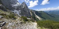

Collapsed Waterfall
Above Čedca Waterfall, Jezersko, Slovenia
June, 19th at 13:00 CEST

Loading panorama viewer ...
Configuring ...
© 2008 Boštjan Burger, All Rights Reserved.
Caption
Čedca waterfall used to be one of the highest Slovenian waterfalls. Its height was 138 m but the collapse of the rockwall where the stream flows had shorten the fall of the water to only 20 m in May/June 2008. This area is now extremely dangerous and the visit is recommended only from the far distance.
This area is nearby the settlement Zgornje Jezersko, which is the municipality centre with the highest elevation in Slovenia.
I started to climb early in the morning above the waterfall. The rock where waterfall flows started to collapse one week ago and the whole mountain is falling apart - extraordinary geomorphologic event! I was equipped as it is needed but it was more for my psycho than really helpful. I am very careful person so I estimated that it maid be quite safe from the other side of the mountain but with additional hours of climbing. When I finally came there it was spectacular feeling but not so good to show the real situation with the VR panorama. I shot couple of panos, handheld. There were literally billons of mountain flies so taking pano was almost mission impossible - flees covered my helmet, face, lens, camera - like to be in a twilight -zone. After returning in the bottom of the valley I visited the 'tricky' area below the waterfall but from the safe distance - it was a serious thread of the avalanche and the access was not recommended - even forbidden (?)...
Location
Lat: 46° 22' 13.58" N
Long: 14° 31' 41.7" E
Elevation: 1.600 m
Precision is: Unknown / Undeclared.
Equipment
Nikon D200, Sigma 8 mm, handheld
 Tap or click the zoom icon in the bottom right corner of the picture to switch between in-page and fullscreen view