WWP Home arrow right This Event arrow right Indices: Alphabetical | Regional | Thumbnail | Map previousPrevious | Nextnext
event title
USA
placeholder Bill Jr
Negative Elevation
Western New York, USA
mini manual

This should be a panorama image.

If you can read this, something went wrong.
We support these player technologies:

With ... you can view ...
Apple QuicktimeVR
(part of Quicktime)
all contributions
Adobe Flash Player 10.1 or newer most (not all, some contributions are QTVR-only due to historical reasons)
Javascript + HTML5 / WebGL many, but depends on photographer's choice of file upload (newer event = more likely to work) and your device's capabilities. You may experience slow playback, distorted images or unexpected browser quitting if there is only limited memory/GPU power available.
[?]
Copyright © 2008 Bill Jr, All Rights Reserved
Buffalo VR
Previous panorama: Sachio IzumifullscreenA-Z Regions ThumbnlsShow in MapNext panorama: Willy Kaemena

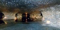
This is an old water limestone mine, its about 50ft underground.

Location Map Geographic Coordinates:
Latitude: 42° 53' 11.29" N
Longitude: 78° 52' 41.56" W
Elevation: -50ft
Precision is: Low. Intentionally hazy, due to privacy concerns.

arrow Show at MultiMap.com [what is MultiMap?]
arrow Show at Google Maps [what is Google Maps?]
arrow Show in Google Earth* [what is Google Earth?]
* requires Google Earth
installed on your computer

Date/Time:
June 21st., 2008

Equipment:
50 tealight candles, a spotlight and a strobe were used for illumination as it is "darkroom" dark down here.


text
WWP Home arrow right This Event arrow right Indices: Alphabetical | Regional | Thumbnail | Map previousPrevious | Nextnext