
Military Cemetery on the Northern Slope
Pulkovo Heights, Saint-Petersburg, Russia
June 19, 2008 - 13:52 UTC (17:52 local time)

Loading panorama viewer ...
Configuring ...
© 2008 Andrew Varlamov, All Rights Reserved.
Caption
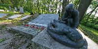
Pulkovo is an area in the south of St. Petersburg,
at the junction of Kievskoe Freeway and the road from the town of Pushkin.
It is located on Pulkovo heights.During the Civil War and the Great Patriotic War pitched battles were fought in this region; in 1941, the advance of German troops towards Leningrad was stopped on this line.
The memorial at Pulkovskoe Military Cemetery was unveiled in 1979.
Authors of the memorial are architect P.F.Kozlov and sculptor Vsevolod Lishev.
Verses engraved were taken from poem "Requiem" written by Robert Rozhdestvensky in 1962: "PEOPLE ! While hearts beat, - REMEMBER ! What is the price of happiness conquered - Please, remember !".
Equipment
Camera: Pentax *ist DSLens: Pentax SMC P-DA Fish-Eye 10-17mm F3.5-4.5 ED (IF)
Tripod: Manfrotto 190XB and Manfrotto 556B Levelling centre column
Tripod Head: Nodal Ninja 3
Software: Software (panorama): PTGui 7.8 by New House Internet Services B.V. (dated by April 2, 2008), MinGW version of PanoTools library 2.8.0 (dated by November 24, 2005) from Jim Watters' PanoTools site, Pano2QTVR version 1.6.6 pro flash by Thomas Rauscher.
Caption in Russian - Воинское кладбище на северном склоне
Пулково - местность на юге Санкт-Петербурга, при слиянии Киевского шоссе и дороги на Пушкин. Располагается на Пулковских высотах.Во время Гражданской и Великой Отечественной войн здесь шли ожесточенные бои; в 1941 году на рубеже Пулково было остановлено наступление германских войск на Ленинград.
Мемориал Пулковского воинского кладбища был открыт в 1979 году.
Авторы мемориала - архитектор П.Ф.Козлов и скульптор Всеволод Всеволодович Лишев.
Стихи, выбитые на плитах, взяты из поэмы "Реквием", написанной Робертом Рождественским в 1962 году.
Behind the scene : how this panorama was made
Ancient and reliable way to reach Pulkovo heights is
to take city bus No.55 (running every 20 to 30 minutes)
from metro station "Moskovskaya" where airports passengers await buses No.13 and 39 to Pulkovo-1 and Pulkovo-2 terminals. Bus stop where You need to get off is on the hilltop in front of closed gates of Pulkovo Observatory.Today it is dusty place, because narrow Kievskoe Freeway is under reconstruction. If to walk down along high iron fence, 200 meters later You can see Grotto fountain with inscription "1807" on its tympanum. Indeed, Grotto was built 2 centuries ago according to project of Andrei Voronikhin and Jean Francois Thomas de Thomon. The Grotto is closed by lock, but iron fence is suitable to install tripod inside Grotto and to shot panorama.
Other fountain with four Sphinxes (built in 1809) is laid near junction of two roads downhill, and today it is hidden under plywood shields.
Entrance to cemetery is between the Grotto and four Sphinxes. When You exit from cemetry through back door (behind the obelisk), narrow road leads to place where mountain bikers like to run between two hills through gully. Behind the second hill forest ends and meadow opens. The main mark of this place is high iron cross welded of rectangular profiles. Here is beautiful view of Saint-Petersburg. It is possible to climb on the roof of metal wagon to view more. It is place where You begin to believe in existence of Pulkovo villages, because land around is divided into plots planted by potatoes and vegetables.
Cemetery seems small, and place for monument is chosen very successfully. I never see monument so close, there was no tall pedestal or wide border. Sun was going to look from the trees and time for shooting was short.
However for this event shooting period was only 4 days long, I had got 3 evenings for theme exploration. My other panoramas are published at viewat.org site - fire lookout tower, bird's-eye view from 23rd level and party for graduates of Academic Gymnasium.
I hope that our new contributions will help GoogleMaps users to look under the foliage and under the roofs. Next time let's help to see them colors !
 Tap or click the zoom icon in the bottom right corner of the picture to switch between in-page and fullscreen view