

Loading panorama viewer ...
Configuring ...
© 2007 Stuart Gibbins, All Rights Reserved.
Caption
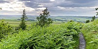
This is part of an ongoing project for a site for the Penistone and District Community Partnership, a local charity. Whilst not strictly reflecting many people's interpretation of "community," this picture, particularly when viewed alongside others in the series helps to illustrate how much the landscape has shaped our community and who we are.
Taken on the 21st June 2007, it's also hours before the downpour which caused so damage soon after, as many in the Uk will know.
More in the series can be seen at http://www.visitpenistone.co.uk/gallery.html
Location
Lat: 53° 30' 50.04" N
Long: 2° 41' 1.2" W
Precision is: Medium. Nearby, but not to the last decimal.
 Tap or click the zoom icon in the bottom right corner of the picture to switch between in-page and fullscreen view