

Loading panorama viewer ...
Configuring ...
© 2007 Patrick Born, All Rights Reserved.
Caption
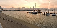
It's dawn, just a few minutes after sunrise, the air is warm and there's hardly a breeze blowing. The lonely call of gulls makes this morning perfect. The temperature is currently in the low eighties (Fahrenheit), around 28 Celsius.Here on Shoreline Boulevard in Corpus Christi, Texas, multiple communities converge in this area based on the time of day, the season, and even the day of week.
Communities that make up this area include:
- The live-on-board community that reside year-round here at Cooper's Alley L-Head and the T-Heads at the Corpus Christi Marina on their water craft (yachts and boats). Click the "Show in Google Maps" link [below], view in hybrid mode, and zoom in to view the L and T-shaped areas.
- The sailing community is very active in the Corpus Christi area. The US Open windsurfing regatta is held in the Corpus Christi Bay. Each Wednesday evening, there's a sailboat race here too. Visit the Corpus Christi Yachting Center, the Corpus Christi Marina, and the Corpus Christi Yacht Club sites for sailing information. Here's a great promotional video from the Corpus Christi Municipal Marina
- The fishing community that brings in daily catches of shrimp to this area.
- The beach-going, sun-worshiping, holiday makers that flock to Corpus Christi at every available opportunity.
- The potter community, throwing pots and working clay at the Art Center of Corpus Christi's Clay Studio. The Art Center of Corpus Christi is the light colored building directly across the road, pan around with your mouse or arrow keys to view it. While visiting the Art Center of Corpus Christi, be sure to stop in at Jezabelles Restaurant for a snack or meal.
- The business community in the downtown area includes the American Bank, with the popular American Bank Center a little further down Shoreline Boulevard.
- The local community driving, running, walking, and cycling along Shoreline Boulevard and then onto Ocean Drive.
- The hungry community visit this area 24 hours a day. Scroll around, see the A-Framed building with the orange and white roof? That's What-A-Burger #113 By the Bay.
Corpus Christi Bay is protected from the Gulf of Mexico by the Mustang and Padre barrier islands
Don't forget to scroll around with arrow keys, if you see something interesting, just zoom in with the shift key to view it better.
Location
Lat: 27° 47' 32.74" N
Long: 98° 24' 30.54" W
Elevation: 8'
Precision is: High. Pinpoints the exact spot.
Equipment
For this immersive image, I used:
- Nikon D70 DSLR (@ISO 200)
- Nikkor 10.5mm f/2.8 lens @ f/8 and 1/6 sec exposure
- Gitzo G2220 tripod
- Manfrotto 303 SPH panorama head
- Photoshop CS2
- PTGui (v5.8.4)
- Peter Nyfeler's Photoshop Nadir Action
- Pano2QTVR (v1.2.10)
 Tap or click the zoom icon in the bottom right corner of the picture to switch between in-page and fullscreen view