
Saint Nicholas Anapafsas Monastery - Meteora, Greece
Meteora, Greece
June 21, 2007 - 12:48PM

Loading panorama viewer ...
Configuring ...
© 2007 Mark Fink, All Rights Reserved.
Caption
About five hours north of Athens, Greece is an area known as Meteora. The closest towns are Kalambaka and Kastraki. Meteora is a geological anomaly for the area. Rock spires jut up from the ground to form a landscape that is captivating to say the least.Sometime during the 15th century, hermits came to the area seeking isolation from the world. Over time, monasteries were built on these formations, literally clinging to the edges with a dizzying view.
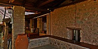
This particular monastery, named after Saint Nicholas Anapafsas, is one of the smaller ones, but is no less impressive. Built on several levels, this porch area looks out over the Meteora landscape, with the town of Kastraki in the near distance.
Ironically, while the initial draw to the area was to escape into solitude, now, thousands of tourists are drawn to the area to see not only the spectacular rock formations but also the monasteries. However, these same tourists help the monasteries survive financially, so it is more of a symbiotic relationship rather than a parasitic one.
http://www.kalampaka.com/anapafsas/index_en.asp
http://www.kalampaka.com/en/meteora/monasteries_nikolaos.asp
http://www.pinnacle-vr.com
http://www.kalampaka.com/en/meteora/monasteries_nikolaos.asp
http://www.pinnacle-vr.com
Location
Lat: 39° 43' 18.36" N
Long: 21° 37' 13.32" E
Elevation: 1196
Precision is: Unknown / Undeclared.
Equipment
Canon 10D, Sigma 14mm, Pinnacle VR Universal Pano head. Three rows of eight images stitched into a final image measuring 6,615 x 13,230 pixels using PTGui and post production in Adobe PhotoShop CS3. TIF converted to MOV using Pano2QTVR.
 Tap or click the zoom icon in the bottom right corner of the picture to switch between in-page and fullscreen view