

Loading panorama viewer ...
Configuring ...
© 2007 Luis Benitez, All Rights Reserved.
Caption
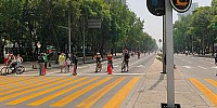
One of the most important avenues and with the biggest car circulation of Mexico City, The "Paseo de la Reforma", is converted in a save and calm track for cyclist every weekend.Every Sunday from 7am to 2pm, this track is used by Mexico City citizens that rides there bicycles to have fun, do exercise or to have a relaxing time. The government of the city organizes this event called ' The family "Ciclotón" ' .
This Images was capture in one the most known and significant points of the City: The turning point of the Paseo de la Reforma and Eje Vial 2 Poniente or Florencia street, where the monument ' El Angel de la Independencia ' (The Angel of Independence) is located.
Location
Lat: 19° 25' 38.18" N
Long: 100° 11' 1.25" W
Elevation: 2249
Precision is: Unknown / Undeclared.
Equipment
Hardware: Nikon D70, AF Fisheye Nkkor 10.5mm, Panosaurus VR Head, 3021BRPRO Manfrotto Tripod, Macintosh PowerBook G4 17;.Software: Nikon Capture NX, Stitcher Unlimited 5.5.4, Phosotoshop CS2, CubicConverter.
Versión en Español
Comudidad de ciclistasUna de las avenidas más importantes y de mayor circulación vehicular de la Ciudad de México, el Paseo de la Reforma, se convierte en una segura y tranquila pista para bicicletas los fines de semana.
Los domingos entre las 7Am y 2PM, esta vía es usada por una comunidad de ciudadanos del Distrito Federal que monta bicicletas para divertirse, hacer ejercicio o relajarse. El gobierno de la ciudad organiza este evento nombrado "El Ciclotón Familiar".
Esta imagen fue capturada en uno de los más significativos y conocidos puntos de la urbe: El cruce del Paseo de la Reforma y el Eje Vial 2 Poniente o calle Florencia, donde se ubica el monumento de El Angel de la Independencia.
 Tap or click the zoom icon in the bottom right corner of the picture to switch between in-page and fullscreen view