
Stonehenge – Prehistoric Stone Ring & Henge
8 miles north of Salisbury, England, UK
June 20, 2007, 11:15 am local time

Loading panorama viewer ...
Configuring ...
© 2007 Lee Nelson, All Rights Reserved.
Caption
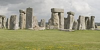
People have been gathering at Stonehenge in the English countryside for over 5000 years. No one knows who built this prehistoric monument, or why, but the evidence suggests that it took as long as 3000 years to complete in several stages so the site may have been used for multiple types of community events.The summer solstice has a particular significance at Stonehenge. A vertical pole at the site would cast shadows from sun up to sun down in a straight line this one day of the year. The arrangement of stones and earlier pits (which may have contained wooden poles) suggest the site may have been some kind of astronomical calendar.
I was fortunate to be able to visit Stonehenge on a day trip from London on the eve of the summer solstice. A large gathering, including modern day Druids, was expected that evening and at sunrise the next morning.
The majority of the people in this panorama are listening to audio devices explaining the history of the megalithic monument, not talking on cellphones as you might assume.
Tour London, New York, San Francisco, Las Vegas, Yosemite NP and more: iNeTours.com
Equipment
Canon EOS Digital Rebel XTi – 400DCanon EFS 10–22mm lens at 10mm (16mm w/1.6 conversion)
Hand held (horizontal) no tripod or spherical head
Adobe Photoshop CS2 software (hand stitched) and Apple QTVRAS
 Tap or click the zoom icon in the bottom right corner of the picture to switch between in-page and fullscreen view