
A School of "Panoramaists"
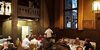
Hillside Club Dinner, Berkeley, California, USA
2000 hrs 19 June 2007

Loading panorama viewer ...
Configuring ...
© 2007 Colin Mackenzie, All Rights Reserved.
Caption
This was taken at the International VR Photography Conference banquet dinner at the Hillside Club in Berkeley just before the keynote speaker, Prof. Helmut Dersch, addressed the community of panorama photographers.
Location
Lat: 37° 51' 22" N
Long: 123° 15' 37" W
Elevation: 360' or 110 meters
Precision is: Medium. Nearby, but not to the last decimal.
Equipment
Canon 5D with 24 - 105mm zoom lens set at 24mm. Three rows of 8 shoots (24 total) stitched into a cylinder Panorama using PTGui. No zenith or nadir shots.The shooting was completely automatic using a "Corybant West electric nodal mount"
 Tap or click the zoom icon in the bottom right corner of the picture to switch between in-page and fullscreen view