

Loading panorama viewer ...
Configuring ...
© 2007 Colin Ewington, All Rights Reserved.
Caption
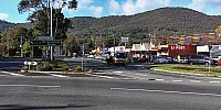
Montrose is a small community located in the foothills of Mt Dandenong.
These cross roads lead up the mountain to the southeast. Travel northeast along Swansea Road to reach Lilydale. Kilsyth and Croydon lay to the south and Mooroolbark to the north.
Location
Australia - New Zealand / Australia
Lat: 38° 49' 36.09" S
Long: 145° 20' 32.5" E
Precision is: High. Pinpoints the exact spot.
Equipment
Nine images shot in RAW using a Canon 30D, 15mm Canon FishEye lens.
Stitched in PTGui, Edited in Photoshop CS, Converted to QuickTime using PhotoWarp 2.
 Tap or click the zoom icon in the bottom right corner of the picture to switch between in-page and fullscreen view