

Loading panorama viewer ...
Configuring ...
© 2007 Stephen White and Chas Adlard, All Rights Reserved.
Caption
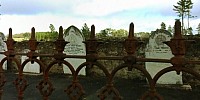
Mount Crawford Cemetery lies near Adelaide, South Australia, amidst a renewable Radiata Pine forest. The early settlers arrived there around 1836 and turned the land to farming. Although the area receives a good rainfall the land supported cattle and sheep rather than crops and in areas away from the forest these graziers still prosper.A descendent of these folk is a good friend of mine and the cemetery has great meaning for me personally as the ashes of my first wife, Barbara, lie there. This is a "community of souls" and the forest a reminder of our frailty. A hundred years of growth surrounded this place with a surreal shadow until a few months ago, when the sun once more penetrated to the ground, thanks to the chainsaws.
Soon fresh young pine plantings will cover the area around the small graveyard and in time their shadows will once more enhance the peace to be found there.
Quoth the raven, "Nevermore"
Sound by dobroide
Georama Pty. Ltd. http://www.georama.com.au
Location
Australia - New Zealand / Australia
Lat: 35° 54' 26" S
Long: 138° 34' 52" E
Elevation: 180
Precision is: Unknown / Undeclared.
Equipment
Nikon D80
Caption in [alternate language]
 Tap or click the zoom icon in the bottom right corner of the picture to switch between in-page and fullscreen view