
Kurpark in Bad Wildbad
Bad Wildbad, Black Forest, South-West corner of Germany
June 25, 2005 - 17:15 UTC (19:15 MESZ = UTC + 2h)

Loading panorama viewer ...
Configuring ...
© 2006 Thomas Rist, All Rights Reserved.
Caption
Founded 1699 by duke Eberhard Ludwig von Württemberg in form of a first "Hainbuchen" avenue, the Kurpark of Bad Wildbad developed itself to one of the largest and also most beautiful landscape gardens in Baden-Wuerttemberg.The tastes in the garden design changed with the time, and thus the Kurpark was subject to a steady change and extension. French garden architecture changed itself off with the naturalness of an apparently unaffected English garden landscape.
In the Kurpark, which stretches about 2.5 km along the river Enz in a narrow valley, you will find plants and trees from all over the world. From American Redwood to Asian Ginko, there are a lot of old and majestic trees present.
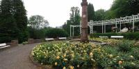
The Roses Garden, where this panorama is taken, was part of the former fenced "Reservierten Kurparks" - accessible only for owner of a cure-card. The terraces with a round pergola and a fountain column were build in 1911/12 by architect Otto Kuhn (1871-1951) - building councilor in the ministry of finance in Stuttgart.
Equipment
Nikon Coolpix 990 + WC-E24, selfmade panohead, PTGui, Photoshop, Pano2QTVR
 Tap or click the zoom icon in the bottom right corner of the picture to switch between in-page and fullscreen view