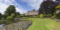

Biddulph Grange Garden
Biddulph Grange, Staffordshire, England, UK
24th June 2006 14:13 GMT

Loading panorama viewer ...
Configuring ...
© 2006 Steve Pendleton, All Rights Reserved.
Caption
Biddulph Grange Garden was created over 150 years ago by the Victorian plant collector James Bateman, his wife Maria and their friend Edward Cooke.Designed as a series of gardens within a garden using a cleverly planned framework of hedges, rocks, banks and planting, each has its own distinctive theme or style. These were then used to create micro-climates to house the varied collection of trees and plants collected from around the world.
In 1988, the National Trust acquired the garden and began a major restoration project. The intention is to recreate the look and feel of the garden as it would have appeared during the period the Batemans lived there between 1841 and 1868.
National Trust Information at: http://tinyurl.co.uk/q0s7
More of my panoramas at: http://www.fullscreenpanoramas.co.uk
Location
Lat: 53° 7' 45.69" N
Long: 3° 10' 44.65" W
Elevation: 546
Precision is: High. Pinpoints the exact spot.
Equipment
Photographed with a Canon EOS 20D and Sigma 8mm Fisheye, using a modified Nodal Ninja SPH1 Pano Head on a Manfrotto 190 tripod. 4 portrait shots taken at 90 degrees and a handheld nadir image. Stitched in PTMac and output to layered PSD. Cube faces created in CubicConverter, nadir patched in Photoshop and final movie output from CC.
 Tap or click the zoom icon in the bottom right corner of the picture to switch between in-page and fullscreen view