
Arid Garden's Tree of Life
Botanical Gardens, Corpus Christi, Texas, USA
12H28 on Saturday, June 24, 2006

Loading panorama viewer ...
Configuring ...
© 2006 Patrick Born, All Rights Reserved.
Caption
About my Shoot
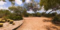
This sequence of images was shot at Corpus Christi's Botanical Garden Arid Garden environment. The temperature is 91 degrees F. in the shade and the time is 12H28, just past midday.View the fullscreen version to hear what was going on while I photographed here. Listen carefully; you should hear the drone of a fly passing by, the joyful song of Cardinals, some water birds, shoes crunching in the hot gravel, vehicles driving on Staples Street, just across from the Oso Creek. You can even hear my camera's shutter mechanism. This recording is "live" but represents only 40 seconds of my 15 minute shoot.
Why I Shot Here
I liked the harshness of this arid environment, peaceful and beautiful in a very rugged way. I stood in the shade of the Mesquite tree (look up) and was amazed at how isolated this area felt, most people being attracted to the beautiful flowers growing in the other environments of the botanical gardens. Look around and see a glimpse of the Oso Creek. I was also intrigued at the aging cactus bloom that looked like it was bowing to the tree of life (Mesquite tree). I shot some additional scenes, see them hereCorpus Christi Botanical Gardens and Nature Center's Handout
The entrance fee includes a small handout full of interesting information. Here are some excerpts:- Arid Garden demonstrates almost waterless landscape possibilities.
- Honey Mesquite (Prosopis Glandulosa) This tree was often called the "Tree of Life" by early people. It provided food, fuel, fiber and wood. The Native Americans and Mexican people used the beans and pods as a food source. The sap was used as glue. We still use the wood for Bar-B-Que. The leaves and seed are an important food source for wildlife. In time of drought, ranchers feed the bean to cattle.
Location
Lat: 27° 39' 17.96" N
Long: 98° 25' 23.18" W
Elevation: about 10'
Precision is: Medium. Nearby, but not to the last decimal.
Equipment
I use Nikon D70 bodies and lenses. For this immersive image, I used:
- 10.5mm f/2.8 lens @ f/8
- Manfrotto 3233 tripod
- Manfrotto 303 SPH panorama head
- Photoshop CS2
- PTGui
- Peter Nyfeler's Photoshop Nadir Action
- Panasonic Digital Recorder
- iTunes
- Audacity
- Pano2QTVR
 Tap or click the zoom icon in the bottom right corner of the picture to switch between in-page and fullscreen view