

Loading panorama viewer ...
Configuring ...
© 2006 Mike Posehn, All Rights Reserved.
Caption
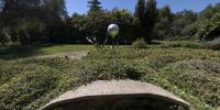
Gail and Scott of Loomis, California created this Cretan Labyrinth in their garden. “It’s not a puzzle, it’s a tool to help you take the time to go inward and reconnect to your higher self. To be healthy we need to connect with mother earth. This is who we are.” A labyrinth is an ancient symbol that relates to wholeness. It combines the imagery of the circle and the spiral into a meandering but purposeful path. It is a walking meditation. Gail and Scott were inspired by Alex Champion’s book “Earth Mazes” when the created this earth mounded labyrinth in 1998.
For questions, please email at loomislabyrinth@gmail.com or for more information on labyrinths please visit http://www.lessons4living.com/labyrinth.htm
Location
Lat: 38° 49' 35.76" N
Long: 122° 11' 44.44" W
Elevation: 401
Precision is: Medium. Nearby, but not to the last decimal.
Equipment
Canon 5D with 15mm fisheye lens mounted on a Really Right Stuff spherical bracket and a Manfrotto panorama head.
 Tap or click the zoom icon in the bottom right corner of the picture to switch between in-page and fullscreen view