

Loading panorama viewer ...
Configuring ...
© 2006 Kat Bennett, All Rights Reserved.
Caption
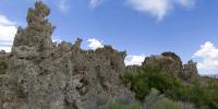
Mono Lake has quite a history and has been well photographed many times over. This lake was first featured in the WWP in 2005 by John Dotta for the Water themed summer Solstice. There is a brief history about Los Angeles and the lake level accompanying the panorama.I was recently there during this Solstice event on my way back from the White Mountains with my husband Landis Bennett. I hadn't been able to get the panorama I had originally thought of in Berkeley and found the tufa here a wonderful subject for this theme of Gardens. This pano is taken in the South Tufa Grove off of Hwy 120 just south and east of Lee Vining.
There are several ways that tufa can be formed. In Mono Lake the tufa forms from underwater springs rich in calcium deposits that precipitate out in the alkaline rich lake. Ordinarily, most of the tufa would be underwater, but due to the lake's history of water diversion from the supplying tributaries for the growing water needs of Los Angeles County the towers have been exposed and are very prominent.
Los Angeles is legally bound to restore the lake back to 1965 water levels. This past year's rainy season has raised the level about 2 feet according to two rangers I spoke with. If this keeps up in subsequent years the Los Angeles obligation may be met in as little as 4-5 years; About 8 more feet is required. Walking along the trail I could see the difference in lake level from my previous visits. Where I think John Dotta took his panorama the trail has become obscured by the water line of the lake (Beware wet sand and water! Wear sandals when walking this trail). It was a very pleasant surprise to find the lake so.
For a brief time I wondered at the change from a gravel path to a wooden boardwalk the closer we walked to the shore. Apparently I missed the sign marking the 1965 water line.
 Tap or click the zoom icon in the bottom right corner of the picture to switch between in-page and fullscreen view