

Loading panorama viewer ...
Configuring ...
© 2006 Joachim Nickel, All Rights Reserved.
Caption
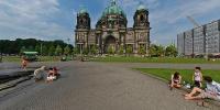
The LustgartenIn 1471 the Lustgarten was first announced in the historical books. Between 1573 and 1618 Kurfürst Johann Georg used it as fruit and vegetable garden for his kitchen.
After the Thirty Years´ War, while it got feral, the Lustgarten was designed tessellated since 1645 for Kurfürst Friedrich Wilhelm. In 1646 he got it´s present name.
Since 1657 the Lustgarten got public and was used as the first botanical garden in town.
Between 1713 and 1826 the Lustgarten was used as a parade-ground.
Through the years the place often changed his face, depending on the political leaders in Berlin and Germany. Sometimes it looks the a green oasis for the collective good, afterwards it looks like a stonedesert just for the demonstration of power of the several leaders.
Around the Lustgarten there rises the Alte Museum, the Dom as well as pieces of the Palast der Republik. The Palast gets teared off, for making place for the Stadtschloss which is planed to be raised again.
Location
Lat: 52° 31' 6.71" N
Long: 13° 23' 59.03" E
Elevation: 38 m
Precision is: High. Pinpoints the exact spot.
Equipment
Nikon D70, Nikkor 10.5mm, Sticher 5, Photoshop CS2, ClickHere's CubicConverter
 Tap or click the zoom icon in the bottom right corner of the picture to switch between in-page and fullscreen view