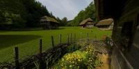

Countryside Garden from the 19th Century
Pleterje, Šentjernejsko polje, Dolenjska, Slovenia
21st June 2006 / 9:30 am CEST (27°C, sultry weather)

Loading panorama viewer ...
Configuring ...
© 2006 Boštjan Burger, All Rights Reserved.
Caption
This small garden at the wooden house is a part of the skansen, open-air museum nearby the Pleterje monastery. Listen the sound track and church bells can be heard. The scene represents 19th century farm from Dolenjska region in Slovenia.
Location
Lat: 45° 49' 5" N
Long: 15° 21' 2" E
Elevation: 260 m
Precision is: High. Pinpoints the exact spot.
Equipment
N D200 + S 8mm
 Tap or click the zoom icon in the bottom right corner of the picture to switch between in-page and fullscreen view