

Loading panorama viewer ...
Configuring ...
© 2006 Bill Ward, All Rights Reserved.
Caption
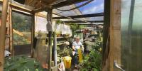
On the top of a hill, surrounded on all sides by tall, leafy trees, in the city of Glasgow, lies the Queens Park Allotments. Completely hidden from view, this 1.1 hectares site hosts about 80 "plots", as they are known. Run by Glasgow City Council this is one site of only a few, provided so that residents can grow their own crops of whatever type they choose - its mostly edible, with very few flowers. If you want one of these council run plots then you'll need to be on a waiting list for about three years, or more - demand is high.This is Dougie's greenhouse, improvised from mostly reclaimed and recycled materials, in the absolutely necessary tradition of constructing a howf for little or no money. This one is a beauty. Here he grows tomatoes, cucumbers and is trying a few watermelons this year. All in the Scottish climate - plenty of water but not a long season of sunshine.
All around the site imaginative use of discarded timber and building materials abounds - many seem to have fences made from old perspex windows, I assume to try to keep out at least some of the many rabbits I saw darting about on this sunny afternoon.
More of these at http://www.billward.org/pages_qu_alots/qu_alot.html
Equipment
Nikon D100, Sigma 8mm, monopod, PTGui, Photoshop, Pano2QTVR
 Tap or click the zoom icon in the bottom right corner of the picture to switch between in-page and fullscreen view