

Loading panorama viewer ...
Configuring ...
© 2005 Roberto Portolese, All Rights Reserved.
Caption
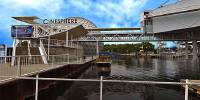
Built more than 30 years ago and still looking futuristic with no aging signs.Ontario Place is an internationally acclaimed cultural, leisure, and entertainment parkland located in Toronto, Ontario, Canada.
The two main objectives in the development of this project were to revitalize Toronto's waterfront and to create a large urban park on a previously neglected segment of the shoreline. Consisting of 90 acres of man-made islands and lagoons, Ontario Place features five exhibition pavilions with a total of 90,000 square feet of space.
The 800-seat Cinesphere IMAX theatre, the world's first Cinesphere introduced many innovations including: single large screen: 80 feet wide by 60 feet high, armchair seating for an audience of 752 people where the outer seats of many rows have the capability of swivelling so that each member of the audience has an equally good perspective. The steep rake of the theatre is designed to ensure an unobstructed view of the screen.
Ontario Place includes a two-acre Children's Village play area, a 300-boat marina, boutiques, restaurants, snack bars, picnic areas, beaches, and three large parking lots as well as a 2,500-seat Forum amphitheatre with 12,000 lawn seats.
A quarter-mile breakwater was formed by the sinking of three Great Lakes freighters and sweeps around to the most southerly portion of the complex. Over 3,000,000 people now visit Ontario Place annually. Zeidler Partnership was responsible for the architectural design and the design co-ordination of all landscaping and artwork throughout the site.
Construction Completion: May 1971 Project Size: 46 acres of man-made island (90 acres of land and water in total)
(Above information from Zeidler Partnership Architects Website & Ontario Place Website)
www.ontarioplace.com
www.zrpi.com
www.zrpi.com
Equipment
Nikon D70, Sigma 12-24, Manfrotto 303 SPH Panohead, Velbon Sherpa 750n Tripod, Realviz Stitcher 4.0, Photoshop Elements 3, Mac & PC.
 Tap or click the zoom icon in the bottom right corner of the picture to switch between in-page and fullscreen view