

Loading panorama viewer ...
Configuring ...
© 2005 Ken Stuart, All Rights Reserved.
Caption
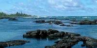
Normally I shoot panoramas with a fisheye lens on a Panoscan or Nikon D70, but for this theme I tried to get a fisheye view using cheap disposable underwater cameras. Unfortunately, between difficult ocean surge, rough wave action, bad lighting, sharp lava rocks and jagged coral, none of the four panoramas I attempted came out well enough to use. My final attempt, which promised to be the best, was destroyed by Wal-Mart during film processing.
So... I reverted to my backup travel camera (not having my standard panorama equipment with me on vacation) to produce the relatively low-tech, handheld panorama on this page.
The Wai'opae Tidepools, revealed by a book called Snorkel Hawai'i: The Big Island by Judy and Mel Malinowski, turned out to be a wonderful place to enjoy the tropical fish, coral, and invertebrates Hawai'i has to offer. I highly recommend this site (and the book) to anyone visiting Big Island with snorkeling gear. But be very careful walking around the flesh-cutting rocks in the area.
These tidal pools vary in size and depth from shallow to several meters deep, and range widely in area as well. A barrier of laval protects them from the sea, so it's a rather safe place for beginners to take up mask and snorkel (no fins are necessary).
If anyone manages to produce a decent underwater panorama for the WWP site them you can trust they are very, very good at what they do.
Location
Lat: 19° 29' 55.49" N
Long: 155° 50' 13.51" W
Elevation: about 1 meter
Precision is: Unknown / Undeclared.
Equipment
Fuji FinePix S7000, 18 handheld horizontal shots at f/7.0 ISO 200 at 1/640 sec. Stitched in Photoshop CS, wrapped in PanaVue ImageAssembler and saved into QuickTime from there.
 Tap or click the zoom icon in the bottom right corner of the picture to switch between in-page and fullscreen view