

Loading panorama viewer ...
Configuring ...
© 2005 Karl Harrison, All Rights Reserved.
Caption
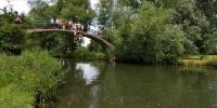
Several children find the water irresistible in the hot UK summer sun !The water is the River Cherwell, a tributary of the River Thames which runs along the edge of the University Parks, though the historic city of Oxford and the joins the River Thames just south of Christ Church meadow.
The bridge is called High Bridge - built in 1923-24 in a relief project for the unemployed and is sometimes also known as Rainbow Bridge. The footpaths over the bridge from the park lead to Wolfson College and to the Marston Ferry Road.
Explore more of Oxford with the Virtual Tour of Oxford, now with over 2600 panoramas in and around the city.
Equipment
Canon 20D, Sigma 8mm lens, 360precision panohead. Manual exposure, custom white balance, ISO 100, fixed focus.
Defish followed by Realviz Stitcher 4, Adobe Photoshop CS2, Cubic Convertor and the Cubic Connector.
 Tap or click the zoom icon in the bottom right corner of the picture to switch between in-page and fullscreen view