

Loading panorama viewer ...
Configuring ...
© 2005 Jim Watters,
Some Rights Reserved.

Caption
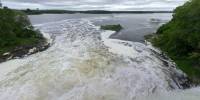
Rideau Falls is located in downtown Ottawa. The Rideau River splits into two just before it joins the Ottawa River. This is one of those two waterfalls. The river gets its French name "Rideau" (curtain) after the Appreciation of the twin waterfalls. The river boat to the right is viewing the other waterfall up close.
Aerial view from Google Maps.
More panoramas of the Rideau Falls and Rideau Canal.
More panoramas and photographs by Jim Watters.
Location
Lat: 45° 26' 27.41" N
Long: 76° 42' 47.94" W
Elevation: 45m
Precision is: High. Pinpoints the exact spot.
Equipment
Nikon Coolpix 995 with Fisheye(FC-E8) lens.18 foot extension pole held over ledge.
CoolRemote Palm Pilot remote control.
13 images in many directions.
Stitched with PanoramaTools using PTGui & Photoshop
Behind the scene : how this panorama was made
I used a three piece expanding pole that extends to 18 feet to capture the panoramas for this event. It is sold at Home Depot as a painting extension pole. The center pole of my tripod is turned upside down and the extension pole sides over top.I failed to bring a connection to join my palm pilot to the camera to use as a cable release so I had to take the camera up and down each time and set a 10 second timer for each shot. Much care was needed to get the camera into the right position each time.
In the case of this panorama only half the pole is out over the falls the other half is behind me as a counter balance. I worked without a safety line on the camera and did not want to loose it.
I did intend to remove myself from the panorama but the shot was taken with way too much parallax error that it could not work.
 Tap or click the zoom icon in the bottom right corner of the picture to switch between in-page and fullscreen view