

Loading panorama viewer ...
Configuring ...
© 2005 Jim Liesenfeld, All Rights Reserved.
Caption
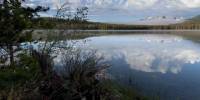
Perched 6493 feet above sea level, Little Redfish Lake was named for the masses of red-scaled salmon that returned there every year to spawn and renew the circle of life. As recently as 1955, more than 4,000 sockeye salmon made the annual pilgrimage from the Pacific Ocean to their ancestral spawning grounds. But by the early 1990s, those numbers were severely diminished. In 1992, a single male sockeye, dubbed Lonesome Larry, returned to Redfish Lake. The Sawtooths Mountains, which tower over the lake, are part of a dramatic range surrounding a glacier carved basin. Once known as Cathedral Peak, Heyburn dominates the Redfish area. The Sawtooth-Stanley country was first seen by whites when a party of John Jacob Astor's fur trappers under Alexander Ross explored it in 1824. They were impressed by the beauty of the country and the abundance of game, including the salmon. The Salmon River, which winds through Idaho to the Snake River is an ancient spawning ground for the saltwater Steelhead trout and Chinook and Sockeye salmon. This fresh water spawning ground on the Salmon River is an amazing 800 miles from the Pacific Ocean.
Today, 200 years after salmon helped keep the Lewis & Clark Expedition from starving in late 1804, 12 species of Columbia and Snake River salmon are listed under the Endangered Species Act as either threatened or endangered. The predominant cause has been construction of over two hundred dams on the Columbia, Snake and its tributaries. The particular villains are the large federal dams on the main Snake and Columbia Rivers. All remaining Snake River salmon and steelhead (ocean-migrating rainbow trout) species are endangered. The dams on the main Columbia were needed to power aluminum production during WWII, but between 1962 and 1975 four additional and superfluous dams were built on the lower Snake River to allow the barging of grain and wood products from Lewiston, ID to Portland, OR. Those four federal dams in southeast Washington were the ones to break the backs of the salmon runs, especially those to and from Idaho.
Equipment
Canon D60, 17-40mm@17, Kaidan QPIII, Photoshop CS, PTMac, CubicConverter
 Tap or click the zoom icon in the bottom right corner of the picture to switch between in-page and fullscreen view