

Loading panorama viewer ...
Configuring ...
© 2005 David Gerhard, All Rights Reserved.
Caption
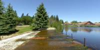
This year, heavy rainfall contributed to widespread flooding in western Canada. Particularly hard-hit was Calgary and other communities in Alberta. As the water flowed eastward along the North and South Saskatchewan rivers, communities in Saskatchewan began to feel the effects. Here in Wolseley, we are fortunate to be upstream on a small tributary that feeds into the Qu'appelle river. Even so, the lake in the center of town is much higher than usual for this time of year. The water is now pouring over the spillway of the dam, which last year was bone dry. This is the same lake I photographed for the "Bridges" world wide panorama event. More details about the history of the lake and the town are available there.
Wolseley is a farming town. Lately it seems there is never the right amount of water for the crops. Too much water and the crops drown and rot. Not enough and they schrivel and die. We know that we depend on water for the functioning of our own bodies, but water (in the right amounts) is also critical to the production of our food, and environmental shifts are changing the way rain falls on our growing lands.
Location
USA-Canada / Canada-Saskatchewan
Lat: 50° 25' 31.44" N
Long: 104° 17' 14.88" W
Precision is: Unknown / Undeclared.
Equipment
Nikon Coolpix 4500, FC-E8 Fisheye Lens, Custom tripod head, PTMac to stitch, 6 shots (North, South, East, West, Zenith, Nadir) using "panorama assist", landscape mode. Photos: 2272x1704.
 Tap or click the zoom icon in the bottom right corner of the picture to switch between in-page and fullscreen view