
The Pergamon Museum - Part of The Berlin Museum Island
Museum Island, in the very center of Berlin, Germany
15:00 UTC

© 2004 Michael Stoss, All Rights Reserved.
Berlin's world-famous Museum Island lies between the river Spree and the canal Kupfergraben. The museum complex on the island consists of several buildings from the 19th and early 20th century, housing archaeological and fine art exhibitions.
During WW II most of this building was severely damaged, other parts on the island destroyed. The ongoing reconstruction work and modernisation will recover the beauty of this cultural heritage complex to its former extent.
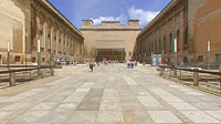
The actual viewpoint is on the bridge over the Kupfergraben canal, in front of the Pergamon Museum. This building was opened in 1930 as the final part of the complex. It houses the Museum of the Ancient Near East with finds from e.g. Babylon.
Further information on the Museum Island can be found here:
www.smb.spk-berlin.de/e/loc/m.html
Further information on the reconstruction can be found here (german only, but a good deal of visual information, try the Flah-version, it's worthwhile):
museumsinsel-berlin.de
 Tap or click the zoom icon in the bottom right corner of the picture to switch between in-page and fullscreen view