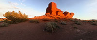

Wukoki Ruins, Wupatki National Monument
Wupatki National Monument (just east of Hwy 89), north of Flagstaff, Arizona, USA
Sunset - 6/20/04

Loading panorama viewer ...
Configuring ...
© 2004 Michael Maersch, All Rights Reserved.
Caption
I first discovered Wupatki National Monument and it's complex of ruins back in the early 1980's. I had recently moved to Arizona from Wisconsin - more because of the adventure, living in such a wild and surreally beautiful place, than because of its world famous weather. (Though you can't beat sunshine and 70° in mid-January, I must confess.)I had seen the Monument on maps, just north of Flagstaff, and had been keen to see my first Anasazi ruins but was busy exploring various trails in the Grand Canyon, the Sedona back country - and a most phenomenal landscape east of Phoenix, the Superstition Mountains - at first.
"Scouting" locations for a large ad campaign provided me the opportunity to become a paid tourist, an expense-paid road trip throughout Arizona making pictures of the "best of" - places and landscapes - for the Lottery's next series of television commercials. As I tend to work for directors and other photographers that most want to shoot a site during "magic hour", at sunrise or sunset, I arranged to come to Wupatki very early one October morning. Wukoki Ruins was the first ruins I came upon driving down from Sunset Crater. The sun was just breaching the horizon...
Wukoki Ruins sits atop a really small hill that rises out of the Painted Desert. The south and east walls of it's tower keep were glowing the most intense orange I had ever seen. One could almost sense a sort of "energy" exuding from the deep red sandstone, made active by the sun's first light.
I imagine how these ancient sandstone "castles", almost all built on the crest of a hill or the edge of small canyons, were a beacon to the ancient traveler navigating cross the great, arid expanses of this magical landscape from one small community to the next.
Location
Lat: 35° 34' 37.09" N
Long: 112° 29' 12.97" W
Precision is: High. Pinpoints the exact spot.
Equipment
Nikon Coolpix 995 w/WC-E63 Wide Converter on Kaidan Spherical Pano head and Hakuba HG-504MX Super Light Weight Carbon/ Magnesium tripod
 Tap or click the zoom icon in the bottom right corner of the picture to switch between in-page and fullscreen view