WWP Home arrow right This Event arrow right Indices: Alphabetical | Regional | Thumbnail | Map previousPrevious | Nextnext
event title
Atlantic
portrait Martin Sammtleben
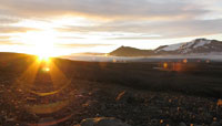
Kaldidalur "The Cold Valley"
Central highlands, Iceland
mini manual

This should be a panorama image.

If you can read this, something went wrong.
We support these player technologies:

With ... you can view ...
Apple QuicktimeVR
(part of Quicktime)
all contributions
Adobe Flash Player 10.1 or newer most (not all, some contributions are QTVR-only due to historical reasons)
Javascript + HTML5 / WebGL many, but depends on photographer's choice of file upload (newer event = more likely to work) and your device's capabilities. You may experience slow playback, distorted images or unexpected browser quitting if there is only limited memory/GPU power available.
[?]
Copyright © 2004 Martin Sammtleben, All Rights Reserved
Wild Photography Holidays
Previous panorama: Scott RowedfullscreenA-Z Regions ThumbnlsShow in MapNext panorama: Helmut Schierer

Kaldidalur, The Cold Valley, is the shortest of the three main routes across Iceland’s central highlands. Its highest point is 727 m above sea level and offers magnificent views on the two glaciers, Langjökull and Þórisjökull, and their surroundings. The panorama was taken at 3:22 AM GMT when the sun finally rose above the low-floating clouds. Þórisjökull can be seen as what appears like a long, snow-topped mountain ridge. It is actually an ancient, sub-glacial shield volcano, topped by a glacier. There’s an aerial photograph, © Jóhann Ísberg, available that shows Þórisjökull in the foreground to the left and its much larger sibling Langjökull to the right, stretching into the distance.

Also see the companion page.


Location Map Geographic Coordinates:
Latitude: 64° 34' 48.36" N
Longitude: 20° 47' 45.6" W
Precision is: High. Pinpoints the exact spot.

arrow Show at MultiMap.com [what is MultiMap?]
arrow Show at Google Maps [what is Google Maps?]
arrow Show in Google Earth* [what is Google Earth?]
* requires Google Earth
installed on your computer

Date/Time:
June 21, 2004, 3:22 AM GMT

Equipment:
Canon A80, custom mount, Apple QuickTime VR Authoring Studio


text
WWP Home arrow right This Event arrow right Indices: Alphabetical | Regional | Thumbnail | Map previousPrevious | Nextnext