
De Oude Haven, Schokland
De Oude Haven, Schokland, Flevoland, The Netherlands
13:00 CET

Loading panorama viewer ...
Configuring ...
© 2004 Edwin Wildeboer, All Rights Reserved.
Caption
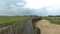
Schokland is a special place: as a symbol of the struggle against the sea, it stands for the history and culture of the Netherlands. For centuries, Schokland was a densily populated island in the Zuiderzee. But the sealevel kept rising and Schokland became smaller and smaller. By the early 19th century the situation had become intolerable, but the Schoklanders refused to give in. In 1859 after repeated flood disasters, the last villages were finally evacuated by royal decree. The island was abandonded to the elements and the Schokland culture came to an end.Till 1932 the island was situated in the Zuiderzee, afterwards (because of completing the Afsluitdijk, the enclosing dyke) in the IJsselmeer. In 1942 a large part of the former Zuiderzee was reclaimed, wich meant that Schokland ceased being an island and could be reached from all sides via the former sea floor.
By the early 19th century a harbour was built in the north of the island, protected by two piers. In 1838 the harbour was totally renewed and offered place to more than 300 fishing boats.
After the evacuation of the island in 1859, the harbour still was in service. A few harbour masters were in charge of the harbour activities. During bad weather fishermen took shelter for storms and fish was being traded.
Between 1915 and 1932 a fish auction was near the harbour. Fish was being bought from the fishermen and shipped to the mainland.
After the reclamation of the Noordoostpolder the harbour lost its function and was demolished for a large part.
The former island is now a museum and the piers of the harbour have been reconstructed, as seen on the panorama. Schokland was added to the UNESCO World Heritage List in 1995.
Location
Lat: 52° 39' 24.98" N
Long: 5° 46' 50.86" E
Precision is: Medium. Nearby, but not to the last decimal.
Equipment
Taken with a Nikon CoolPix 900s, Nikon 0.66x Wide Angle Converter WC-E24 (24mm). Mounted on a Manfrotto tripod with Super Pro Head and Kaidan Kiwi 900/950 panohead. Processed with Adobe Photoshop 5.5 and PanoTools 2.2.0 for dewarping, stiched with QTVR VR Authoring Studio 1.0.1.
 Tap or click the zoom icon in the bottom right corner of the picture to switch between in-page and fullscreen view