
Basilica of San Vitale
Basilica di San Vitale, Ravenna, Emilia-Romagna, Italy
Sunday, June 20 2004 17:57 CEST

Loading panorama viewer ...
Configuring ...
© 2004 Claudio Lanconelli, All Rights Reserved.
Caption
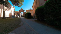
In the first part of the fifth century, the tiny city of Ravenna replaced giants Milan and Rome as the capital of the Roman Empire. Ravenna's seaport proximity to Constantinople made it an ideal governmental location, and under Justininan, Ravenna became the Italian seat of Byzantium. Justinian ascended to power in 527, ruling until 565 as pope as well as emperor of the Roman Empire. In doing so, Justinian was following the example set by his predecessor Constantine, who had been the first ruler to invoke caesaropapism, the emperor's power as both secular, governmental ruler and leader of the Christian faith.Octagonal plan church, founded by Giulianus Argentarius, commissioned by Bishop Ecclesius and consecrated by the Archbishop Maximian in 548, the Basilica of San Vitale is a unique example of byzantine art; firstly because it blends in a most original way eastern and western styles into its architecture and secondly because its mosaics are complete and express with great clarity the ideology and religiosity of the Justinian era which has been defined by the historians as the First Golden Age of Byzantine Art.
Unfortunately I did not have the permission in order to photograph the inner ones with the splendid mosaics.
Equipment
Taken with a Nikon D70 digital SLR, 8mm 3,5 Peleng lens, f.11 at 1/60 second. Handheld with a "Philopod". Software: Hugin (gui of panotools), Autopano, Enblend, Panocube.
 Tap or click the zoom icon in the bottom right corner of the picture to switch between in-page and fullscreen view