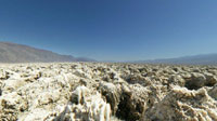

Devil's Golf Course in Death Valley California
Death Valley National Park (248 feet below sea level), California, USA
4:06 PM

Loading panorama viewer ...
Configuring ...
© 2004 Bo Lorentzen,
Some Rights Reserved.

Caption
The Death Valley saltpan is one of the largest saltpans in North America. The bizarre terrain of an evaporated lake contains crystals of almost pure salt, the kind you know from the dining table The craggy lake bottom is complex and intricate with crystals in various stages of development. Deposited by ancient salt lakes and shaped by winds and rain, the crystals are forever changing. Salt continues to be deposited by recurring floods that occasionally submerge the lowest parts of the valley floor.
 Tap or click the zoom icon in the bottom right corner of the picture to switch between in-page and fullscreen view