
De México Tenochtitlan a la Nueva España
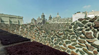
Templo Mayor, México Distrito Federal, México
10:00 a.m. (GMT -6:00)

Loading panorama viewer ...
Configuring ...
© 2004 Felipe B. González Carrasco and Aura Castro López, All Rights Reserved.
Caption
Tenochtitlan, the capital city of the Aztec empire was founded in 1325. The "Templo Mayor" was the religious core of the city, it had twin buildings devoted to Tlaloc and to Huichilopochtli, the gods of rain and war. In 1521 the aztecs were conquered by the spaniards, and what once was Tenochtitlán became the captal of the "Virreinato de la Nueva España". All of the ancient temples were destroyed and new buildings were constructed over them.
In 1978 a huge project dug out part of the aztec city, now we can visit the temple of the conquered side by side with the temple of the conqueror.
Equipment
Sony DSC85 with Raynox DCR-FE 180 Pro adapter, handheld panorama stitched with PTMAC 2.0, retouched with Photoshop CS and converted with Cubic converter
 Tap or click the zoom icon in the bottom right corner of the picture to switch between in-page and fullscreen view