WWP Home arrow right This Event arrow right Indices: Alphabetical | Regional | Thumbnail | Map previousPrevious | Nextnext
event title
Europe
portrait Robin Wilson
Ruthrieston Pack Bridge
Aberdeen, Scotland, UK
mini manual

This should be a panorama image.

If you can read this, something went wrong.
We support these player technologies:

With ... you can view ...
Apple QuicktimeVR
(part of Quicktime)
all contributions
Adobe Flash Player 10.1 or newer most (not all, some contributions are QTVR-only due to historical reasons)
Javascript + HTML5 / WebGL many, but depends on photographer's choice of file upload (newer event = more likely to work) and your device's capabilities. You may experience slow playback, distorted images or unexpected browser quitting if there is only limited memory/GPU power available.
[?]
Copyright © 2012 Robin Wilson, All Rights Reserved
Panoramas of Scotland
Previous panorama: Clifford P. WilliamsfullscreenA-Z Regions ThumbnlsShow in MapNext panorama: John Wilson

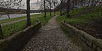
This path follows one of the original routes you would have taken when entering or leaving Aberdeen around 1700 AD. At this point the path crosses over the Ruthrieston Burn by means of this pack bridge, built in 1693, it originally had no parapets so that wide cartloads could easily pass. The parapets were added in 1923 when the bridge was moved the short distance to its present site.

More: Panoramas of Scotland.

Location Map Geographic Coordinates:
Latitude: 57° 7' 32.54" N
Longitude: 2° 7' 5.42" W
Precision is: High. Pinpoints the exact spot.

arrow Show at MultiMap.com [what is MultiMap?]
arrow Show at Google Maps [what is Google Maps?]
arrow Show in Google Earth* [what is Google Earth?]
* requires Google Earth
installed on your computer

Date/Time:
March 20, 2012, 1:15 pm

Equipment:
Canon 350D with Sigma 8mm. Stitched with: PTMac


text
WWP Home arrow right This Event arrow right Indices: Alphabetical | Regional | Thumbnail | Map previousPrevious | Nextnext