WWP Home arrow right This Event arrow right Indices: Alphabetical | Regional | Thumbnail | Map previousPrevious | Nextnext
event title
USA
portrait Robert Agnel
Watts Creek Recreational Pathway
Kanata, Ontario, Canada
mini manual

This should be a panorama image.

If you can read this, something went wrong.
We support these player technologies:

With ... you can view ...
Apple QuicktimeVR
(part of Quicktime)
all contributions
Adobe Flash Player 10.1 or newer most (not all, some contributions are QTVR-only due to historical reasons)
Javascript + HTML5 / WebGL many, but depends on photographer's choice of file upload (newer event = more likely to work) and your device's capabilities. You may experience slow playback, distorted images or unexpected browser quitting if there is only limited memory/GPU power available.
[?]
Copyright © 2012 Robert Agnel, All Rights Reserved
Amarak Internet Marketing - Ottawa Panoramas
Previous panorama: Chas AdlardfullscreenA-Z Regions ThumbnlsShow in MapNext panorama: Rodrigo Alarcón-Cielock

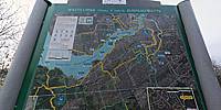
This location, at March Road in Kanata, is at the western end of the National Capital Pathway Network. There are more than 236 kilometres of recreational paths linking natural areas, parks, gardens, museums with local and national attractions in Ottawa and Gatineau.

From here to Parliament Hill in central Ottawa is 22.6 km.

Location Map Geographic Coordinates:
Latitude: 45° 19' 38" N
Longitude: 75° 53' 19" W
Elevation: 88 m
Precision is: High. Pinpoints the exact spot.

arrow Show at MultiMap.com [what is MultiMap?]
arrow Show at Google Maps [what is Google Maps?]
arrow Show in Google Earth* [what is Google Earth?]
* requires Google Earth
installed on your computer

Date/Time:
Friday, March 23, 2012, 18:30 (EST)

Equipment:
Nikon D90 with a Nikkor 10.5mm fisheye


text
WWP Home arrow right This Event arrow right Indices: Alphabetical | Regional | Thumbnail | Map previousPrevious | Nextnext