
Carlos Eduardo Souquett García
Camino de Los Españoles
Cerro Avila, Caracas, Venezuela
March 25, 2012, 13:00 hrs local time

Loading panorama viewer ...
Configuring ...
© 2012 Carlos Eduardo Souquett García, All Rights Reserved.
Caption
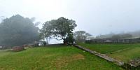
"The Way of the Spanish" is a path in the Avila National Park, Venezuela, that ranges from Caracas to La Guaira. The road was ordained in May, 1589, by the Governor and Captain General of the Province of Venezuela and founder of the port of La Guaira, Don Diego de Osorio. As there is evidence in a report dated January 4, 1603, he finally gave the command to build a trail or pica called "La Culebrilla". The course of this road had forts that controlled and guarded the road and the city from its height and view. Some of the original constructions have been preserved.This pano was taken in the Castillo de San Joaquin, Fort Summit or the knife, construction of 1770 (this fort is the largest of all). In 1981 it was restored and the still standing exterior walls and a well with a depth of five meters. Its view was of utmost importance for the protection of the road and the city.
On December 21, 1799, Alexander von Humboldt was arrested in this castle on suspicion but released immediately coming to Caracas a few hours later the same day.
Location
Lat: 10° 32' 20.5" N
Long: 67° 56' 51.77" W
Elevation: 1.470 mts
Precision is: Unknown / Undeclared.
Equipment
Nikon D300s, Nikkor 10.5mm, Nodal Ninja, Manfrotto Tripod, Photoshop, Pano2VR, PTGui
 Tap or click the zoom icon in the bottom right corner of the picture to switch between in-page and fullscreen view