

Loading panorama viewer ...
Configuring ...
© 2011 Willy Kaemena, All Rights Reserved.
Caption
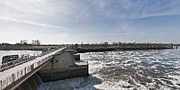
The barrage on the river Weser in Bremen is the limit of the lower Weser and the middle Weser rivers. It also limits the tidewater. The difference is about 3m between high tide and low tide. Currently a hydro power plant with an output of 10MW is being constructed here.
Location
Lat: 53° 3' 38.71" N
Long: 8° 51' 52.84" E
Elevation: 15
Precision is: High. Pinpoints the exact spot.
Equipment
Nikon D300 with Sigma 8mm 3.5 on tripod and two stacked monopods
 Tap or click the zoom icon in the bottom right corner of the picture to switch between in-page and fullscreen view