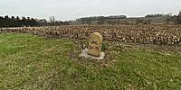

4 to "L" 21 "M"
Harrisburg Ave., Lancaster, Pennsylvania, USA
March 25, 2011, 10:00 am EST

Loading panorama viewer ...
Configuring ...
© 2011 Russ Addie, All Rights Reserved.
Caption
Today at times our travel seems unlimited, but when Harrisburg Ave. was made it was in the days of the horse and buggy and carriages. To that end they had to watch their limits. Horses could only go so far, you certainly would only walk a certain distance and needed to know your limits. On Harrisburg Ave. there are a few of these really old sandstone road markers still left. This one 4 to “L” 21 “M” signifies that there were 4 miles to go if you went east to Lancaster and 21 miles going west to Marietta. Down the road 1 mile is a second one of these stone markers with 3 “L” and 22 “M” on it. I would imagine that there were many of these marker stones every mile but I have traveled this road many times and have only seen 3 still in existence. So as I roll on by at a speed they could only have imagined I’ll take a moment to think about the past, their limits, and how they used these amazing pieces of stone to help them control their travels and to stay within their own personal limits.
www.zoomhome.com
Equipment
Canon 40D, Costal Optics lens, Manfroto tripod, iPIX sticher, Photoshop
 Tap or click the zoom icon in the bottom right corner of the picture to switch between in-page and fullscreen view