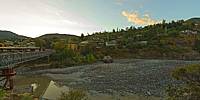

Quebrada Coya
Quebrada de Coya, Sexta Region, Chile
March 22, 2011, 18:47 local time

Loading panorama viewer ...
Configuring ...
© 2011 Patricio Armijo, All Rights Reserved.
Caption
Spanish Caption
El lugar establece el límite de las antiguas instalaciones en coya perteneciente a Braden Cooper Company, con el pueblo de coya. Antiguamente, en este lugar operaba la central eléctrica que proveia de energia a la mina El Teniente, hoy en día en las cercanias se encuentra la nueva central hidroeléctrica Coya-Pangal.Este lugar se situa en la quebrada coya donde fluye el cause del rio cachapoal.
English Caption
The place sets the limit of the old facilities owned by the coya Braden Cooper Company, with the town of Coya. Formerly in this place ran the power plant that supplied power to the El Teniente mine, now nearby is the new power plant Coya-Pangal.This place is situated in the Coya gorge where the Cachapoal river flows.
Location
Lat: 35° 13' 21" S
Long: 71° 32' 44" W
Precision is: Medium. Nearby, but not to the last decimal.
Equipment
Canon 550D + Tokina 107 ATX Pro + Monopod + Nodal Ninja 3 MkII
 Tap or click the zoom icon in the bottom right corner of the picture to switch between in-page and fullscreen view