

Loading panorama viewer ...
Configuring ...
© 2011 Maciej G. Szling, All Rights Reserved.
Caption
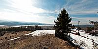
Kluszkowcami towering over a characteristic, a volcanic cone—is top Wdżar rising to a height of 767 m above sea level, dormant volcano, which ended its activity millions of years ago. At the top of the mountain there is a magnetic anomaly resulting from the geological structure Wdżaru (one of two places in Europe where the compass, he loses his head "and changes its position by 180°). Curiosity stirs up the past. Since 1870 there existed a quarry operator of andesite, now closed, is a great place to practice rock climbing and enjoy the unique geology of the top Wdżar.
Nad Kluszkowcami góruje charakterystyczny, wulkaniczny stożek – to góra Wdżar wznosząca się na wysokość 767 m n.p.m., uśpiony wulkan, który swą aktywność zakończył wiele milionów lat temu. Na szczycie góry występuje anomalia magnetyczna wynikająca z budowy geologicznej Wdżaru (jedno z dwóch takich miejsc w Europie, gdzie kompas ,,traci głowę” i zmienia swoją pozycje o 180°). Ciekawość rozbudza przeszłość góry. Od 1870 roku istniał tu kamieniołom eksploatujący andezyt, dziś już nieczynny, jest wspaniałym miejscem do uprawiania wspinaczki skałkowej i podziwiania unikalnej budowy geologicznej góry Wdżar.
http://www.szling.com Breath taking panoramic images :)
Equipment
Sole right system Nikon Forever
 Tap or click the zoom icon in the bottom right corner of the picture to switch between in-page and fullscreen view