

Loading panorama viewer ...
Configuring ...
© 2011 John Wilson, All Rights Reserved.
Caption
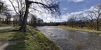
The River Don rises in the Grampian Mountains and flows eastwards through Aberdeenshire to the North Sea at Aberdeen. The panorama shows the river at its Normal Tidal Limit approximately 2 km from the sea.The modern name Aberdeen literally means between the Dee (the other local river) and the Don. The Normal Tidal Limit is the point at which the level of a river or stream ceases to be affected by the tidal flow.
 Tap or click the zoom icon in the bottom right corner of the picture to switch between in-page and fullscreen view