

Loading panorama viewer ...
Configuring ...
© 2011 Henk Keijzer, All Rights Reserved.
Caption
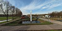
The water-level gauge, in the Rokkeveen Quarter in the city of Zoetermeer, was erected 19 years ago when this area was the scene of the Floriade, the World Horticulture Expo, held every ten years in The Netherlands (the next
Floriade is in 2012 in Venlo). The gauge showed the visitors of the expo that the ground level of the exhibition terrain is about 5.50 meters (18 feet) below sea level. The red markers at about eye level on the gauge indicate average sea level (NAP, Normaal Amsterdams Peil). A normal high tide is about 1.20 meters (4 feet) above that.
Equipment
Olympus E-30Peleng 8mm/f3.5
handheld
Hugin
Smartblend
Photoshop
 Tap or click the zoom icon in the bottom right corner of the picture to switch between in-page and fullscreen view