

Loading panorama viewer ...
Configuring ...
© 2011 Gerardo A. Sanchez, All Rights Reserved.
Caption
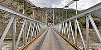
Chama RiverRivers are limits, historically it has been used to set limits between counties, states or countries. It has been limits also for people to move from one place to other place. Here is a picture from the main river in Mérida state, Venezuela: "Chama River". You are looking over a old bridge that connect the main route, which is few kilometers over, to small villages in the south part of Mérida State
Note: there are no stitching problems on this picture, brake part on the structure is real, maybe a big truck made it :-)
Río Chama
Ríos son limites. Históricamente han sido utilizados para fijar limites entre municipios, estados o países. Los ríos también se constituyen en limites que impiden el movimientos de personas desde un lugar a otro. Aquí usted está sobre el Río Chama, el principal río del estado Mérida en Venezuela.
Location
Lat: 8° 29' 28.03" N
Long: 72° 20' 50.18" W
Elevation: 1400 asl
Precision is: Unknown / Undeclared.
Equipment
Nikon D90, Sigma 8mm, Nodal Ninja panohead. Software: PanoTools, PTGui, Smartblend, Adobe Photoshop CS5
 Tap or click the zoom icon in the bottom right corner of the picture to switch between in-page and fullscreen view