
The Downtown Hamilton Limits of Winter Snow
Hamilton, Ontario, Canada
March 25, 2011, 19:30 EST

Loading panorama viewer ...
Configuring ...
© 2011 Francis Fougere, All Rights Reserved.
Caption
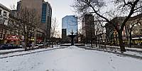
This project started as an exercise to show the limits of the downtown Hamilton core around the Gore Park Fountain and became an exercise about dealing with the limits of a prolonged winter with yet another dump of snow at the end of March.The original Gore Park Fountain was erected in 1860. The fountain was fed by the new city water works steam pump as can be seen at The Hamilton Museum of Steam and Technology. By 1959 it had deteriorated to the state where it was considered unsafe and was removed. In 1996, as a sesquicentennial project spearheaded by the Head-of-the-Lake Historical Society, a replica fountain was installed at the present location in Gore Park. The top bowl and spiral are components saved from the original fountain and the rest was cast by the McCoy Foundry based on the original design.
Location
Lat: 43° 15' 22.65" N
Long: 80° 53' 5.39" W
Elevation: 96 meters
Precision is: High. Pinpoints the exact spot.
Equipment
A Canon EOS 5D with a Canon 16-35mm L-series lens set at 16mm was used on a Manfrotto 303SPH head. The spherical panorama was stitched together with RealViz Stitcher V4. This panorama was shot with available light at 1/15 of a second @ f8 in RAW mode with an ISO of 200 on the Canon EOS 5D. I processed all of the images in the RAW conversion software Camera Raw 4.6 from Adobe.
 Tap or click the zoom icon in the bottom right corner of the picture to switch between in-page and fullscreen view