
National Limits
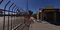
USA/Mexico Border Crossing, Lukeville, Arizona, USA
March 18, 2011, 19:22 UTC (12:22 local time)

Loading panorama viewer ...
Configuring ...
© 2011 David Schaubert, All Rights Reserved.
Caption
National Borders establish limits on movement in every corner of the world.This pano was taken at the Lukeville Border Crossing Station in Organ Pipe Cactus National Monument, Arizona. This was the only place in the park I could approach the border close enough for a panorama as in most areas no-one is allowed to approach within a mile of the line on the USA side.
The Mexican Border Station can be seen through the bars.
Location
Lat: 31° 52' 49.5" N
Long: 113° 50' 2.5" W
Elevation: 424
Precision is: High. Pinpoints the exact spot.
Equipment
Canon XTi (400D) DSLR, Sigma 8mm f3.5 fisheye lens, Velbon D-580 Tripod, Nodal Ninja 3 (NN3) Pano Head, Apple MacPro Dual/Quad 2.8GHz XEON, PTGui Pro 8.310, Photoshop CS5 Extended, CubicConverter 2.2.1
 Tap or click the zoom icon in the bottom right corner of the picture to switch between in-page and fullscreen view