

Loading panorama viewer ...
Configuring ...
© 2011 Bob Bright, All Rights Reserved.
Caption
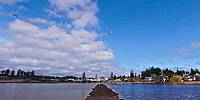
There is a large field across the street from my home in Victoria known as Panama Flats. Until a few years ago, the field was planted with seasonal crops such as corn and potatoes in the summer, and frequently flooded to a depth of several inches or more in the winter, when the small stream which skirts the southwest side of the property overflowed its banks during heavy rains. During very cold winters, the Flats would sometimes freeze over for several days running, creating a wonderful 25-hectare outdoor rink which attracted hundreds of recreational skaters and pond hockey players. Here is a link to another WWP contribution which shows how the property looked in September 2007, just after the potato crop had been harvested and the Canada geese had moved in to clean up the leftovers.In 2009 the Island Berry Company purchased Panama Flats with the intention of planting blueberries. (They subsequently decided that the property was better suited to cranberry production, though this didn't substantially alter their plans for "improving" it.) They undertook to build a system of berms around and across the field, in an effort to limit the seasonal flooding and prepare it for perennial planting. Evidently, though, they underestimated the water retention capability of the underlying clay subsoil. The berm was completed in the fall of 2010. Add a dollop of unusually wet Pacific Northwest winter weather, and the result is what you see here: the berms which were intended to limit flooding of the property have in fact limited its natural drainage, creating a small lake.
Overall, the project is a nice illustration of the limits on our ability to control nature in predictable ways. Panama Flats has now been purchased by the Municipality of Saanich for the sum of $2.4 million. They intend to insure that the property remains available as a floodplain in order to moderate water flow in the region, but beyond that no firm decisions have been made about potential uses. The seagulls are lobbying hard to keep the berms intact.
Vancouver Island Digital Imaging, http://VictoriaVR.ca
Location
USA-Canada / Canada-British Columbia
Lat: 48° 28' 25.69" N
Long: 124° 25' 3.95" W
Precision is: High. Pinpoints the exact spot.
Equipment
Canon 5D Mark II, Nodal Ninja 3 pano head, homemade pole; stitching in hugin, post-processing in the GIMP
 Tap or click the zoom icon in the bottom right corner of the picture to switch between in-page and fullscreen view