

Loading panorama viewer ...
Configuring ...
© 2011 Arie P. de Ruiter, All Rights Reserved.
Caption
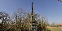
One of six banpalen (banning poles) which were erected, after 1544, in a circle around Amsterdam at a one-mile distance from the city limits (1 German mile = approx. 7.5 km). Convicted criminals and other exiles had to stay outside this area of jurisdiction. Three of the banpalen are still in their approximate original locations (Amsteldijk and Amsterdamseweg in Amstelveen, and Sloterweg in Sloten) and a fourth has been put back close to its original position recently (Spaarndammerdijk).
Equipment
Nikon D300 + Nikkor 10.5mm fisheye + Nodal Ninja 3
Photoshop CS5 + PTGui Pro 9.0.3 + Pano2VR 3.0 + krpano 1.0.8.12
 Tap or click the zoom icon in the bottom right corner of the picture to switch between in-page and fullscreen view