
The English Cucunber and the Beverly Greenhouses
Waterdown, Ontario, Canada
March 22, 2010, 10:30 EST

Loading panorama viewer ...
Configuring ...
© 2010 Francis Fougere, All Rights Reserved.
Caption
Beverly Greenhouses Ltd.
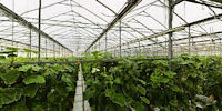
Located in Waterdown, Ontario, Canada, Beverly Greenhouses is one of Ontario’s 118 greenhouse cucumber growers. Established by the VanderHout family, Beverly Greenhouses has been growing greenhouse English cucumbers for 32 years and now has 15 acres of greenhouse production. Ontario English cucumbers are known or their thin skins, lush flesh and delicate flavour. Ontario has 248 greenhouse vegetable growers with a total of 1,824 acres of cucumbers, tomatoes and peppers. All Ontario greenhouse vegetables are grown using hydroponics, which means they are grown using water and nutrients instead of soil.Location
Lat: 43° 17' 59" N
Long: 81° 4' 45" W
Elevation: 80:03:45W
Precision is: High. Pinpoints the exact spot.
Equipment
A Canon EOS 5D with a Canon 16-35mm L-series lens set at 16mm was used on a Manfrotto 303SPH head. The cubic panorama was stitched together with RealViz Stitcher V4. This panorama was shot with available light at 1/160 of a second @ f8 in RAW mode with an ISO of 320 on the Canon EOS 5D. I processed all of the images in the RAW conversion software Camera Raw 4.6 from Adobe. The images were then stitched together in RealViz Stitcher and the QuickTime panoramas are then converted from the flat TIFF images
 Tap or click the zoom icon in the bottom right corner of the picture to switch between in-page and fullscreen view