

Loading panorama viewer ...
Configuring ...
© 2010 Carl von Einem, All Rights Reserved.
Caption
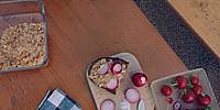
The spring equinox of 2010 in Bavaria brought nice and warm weather, calling for a spontaneous start of the beer garden season. The Hofbräukeller in Munich correctly uses the term cellar in its name for this type of open air restaurant was by definition situated on top of the breweries' cellars which were needed to store the beer and keep it cold. A special feature about Bavarian beer gardens is - besides the tasty beer - the traditional rule that guests are allowed to bring their own food. One source in this case could be the daily food market just around the corner. Some people however take the time and prepare one of the typical specialities that fit together really well with a big mug of beer and a fresh pretzel. I decided to have some freshly made Obatzda, a savoury cheese spread typical of Bavaria. Just perfect together with some radishes on a slice of my favourite bread from a nearby bakery.
Location
Lat: 48° 8' 4.07" N
Long: 11° 35' 41.35" E
Elevation: 526 m (1.725 ft)
Precision is: High. Pinpoints the exact spot.
Equipment
- camera:
Zeiss-Ikon SW 35mm format rangefinder camera
lens:
Voigtländer 12 mm Heliar (1/15 sec., f16)
film:
Kodak Ektar 100 ISO color negative film
- panohead:
Novoflex (still with an antique Manfrotto rotator)
- tripod:
Novoflex BasicBall (with Minipod Extension Set)
- 16-bit scans:
Nikon LS-4000 ED w/ SA-30 film roll adapter (SilverFast Ai 6.6 scan software)
- stitching software:
hugin 2010.1.0-svn5093 built by Harry van der Wolf for Mac OS X (Thanks!)
- additional software:
Photoshop CS, Pano2VR
 Tap or click the zoom icon in the bottom right corner of the picture to switch between in-page and fullscreen view