WWP Home arrow right This Event arrow right Indices: Alphabetical | Regional | Thumbnail | Map previousPrevious | Nextnext
event title
USA
portrait Tim Hatch
Devereaux Slough
Goleta, California, USA
mini manual

This should be a panorama image.

If you can read this, something went wrong.
We support these player technologies:

With ... you can view ...
Apple QuicktimeVR
(part of Quicktime)
all contributions
Adobe Flash Player 10.1 or newer most (not all, some contributions are QTVR-only due to historical reasons)
Javascript + HTML5 / WebGL many, but depends on photographer's choice of file upload (newer event = more likely to work) and your device's capabilities. You may experience slow playback, distorted images or unexpected browser quitting if there is only limited memory/GPU power available.
[?]
Copyright © 2009 Tim Hatch, All Rights Reserved
Tim Hatch
Previous panorama: Gabi HaindlfullscreenA-Z Regions ThumbnlsShow in MapNext panorama: K. Wayne Heil

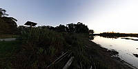
The Santa Barbara area is rather diverse, as you can go from beach, to medium-sized city, to "mountain," and desert within just a few miles. The "mountain" can be seen opposite the starting view, and the slough goes out to the ocean (see the aerial view in one of the maps).

This borders the edge of the University of California Santa Barbara where they do quite a bit of ocean/biology research.

Location Map Geographic Coordinates:
Latitude: 34° 24' 52.95" N
Longitude: 119° 52' 25.82" W
Precision is: Medium. Nearby, but not to the last decimal.

arrow Show at MultiMap.com [what is MultiMap?]
arrow Show at Google Maps [what is Google Maps?]
arrow Show in Google Earth* [what is Google Earth?]
* requires Google Earth
installed on your computer

Date/Time:
March 23, 2009 20:19 (PDT)

Equipment:
Peleng 8mm, Canon 350D, Nodal Ninja 3 on a cheap tripod.


text
WWP Home arrow right This Event arrow right Indices: Alphabetical | Regional | Thumbnail | Map previousPrevious | Nextnext