

Loading panorama viewer ...
Configuring ...
© 2009 Pat Rooney, All Rights Reserved.
Caption
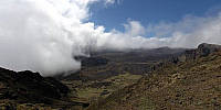
The first week of Spring I spent with friends hiking through Maui's Haleakala National Park. The average elevation of the crater floor is around 2,050 meters (6,700 feet) and hosts numerous environments. Unique species, contrasting weather and a variety of geological features make the crater a wondrous attraction.
Location
Lat: 20° 45' 20.21" N
Long: 157° 14' 5.92" W
Elevation: 2340 meters, 7648 feet, 1.45 miles
Precision is: High. Pinpoints the exact spot.
Equipment
Canon 5D, Sigma 8mm, handheld, PTGui Pro 8.1.2
 Tap or click the zoom icon in the bottom right corner of the picture to switch between in-page and fullscreen view